Projects
Treasure Mountain Silver Project
Quick Facts
Ownership
100%
Location
Near Hope, BC, Canada
Status
Care & Maintenance / Exploration
Operation
Underground Mine
Commodity
Silver (Primary), with Lead & Zinc


Project Overview
Location
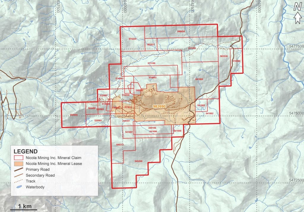
The Treasure Mountain mine property, under the full ownership of Nicola Mining Inc., is located within the Similkameen Mining Division in BC. Positioned 29 kilometers northeast of Hope, BC, this property is conveniently accessible via a 3-hour drive from Vancouver, BC. The property consists of 31 mineral tenures, which include 30 mineral claims and a single mineral lease, spanning an area exceeding 2,200 hectares.
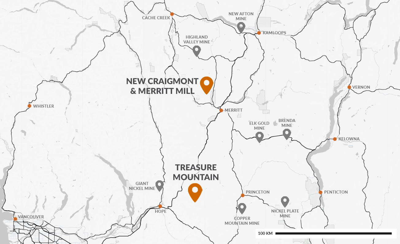
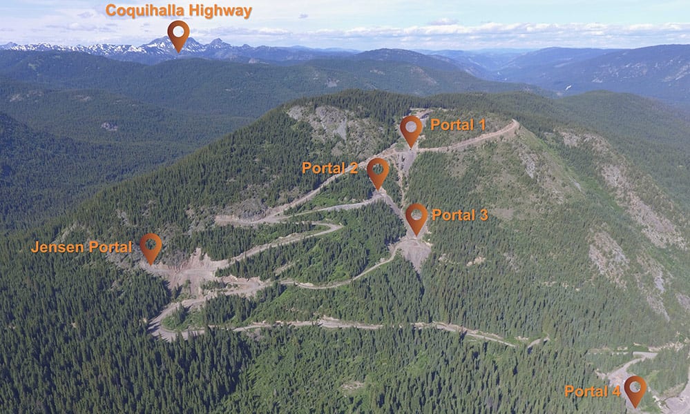
Access to the Treasure Mountain mine is facilitated by an unpaved seasonal road that connects directly with the Coquihalla Highway. The infrastructure around the property is well-developed, with electrical power available near Tulameen village, located approximately 28 kilometers to the east of the site.
Geological Setting & Mineralization
The Treasure Mountain property hosts polymetallic veins including those of the historic Treasure Mountain silver-lead-zinc mine. This property is situated in the northward continuation of the Cascade Mountains of Washington State, which contains sedimentary and volcanic rocks of Late Paleozoic to Cretaceous age plus younger intrusions and sediments.
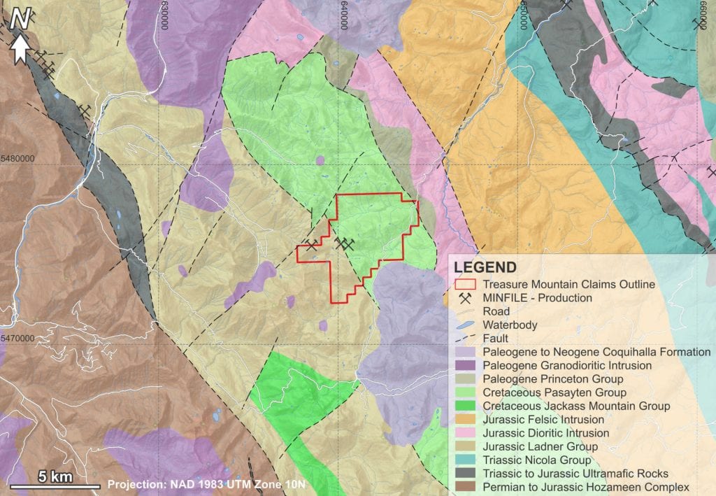
The property is dominated by two primary geologic units. The first is the Jurassic Dewdney Creek Formation, part of the Ladner Group, which is predominantly made up of fragmental volcanic rocks, with sedimentary members comprising approximately 25% of its composition. The second unit is of the Cretaceous period, belonging to the Pasayten Group, which is primarily sedimentary, composed of arkose, argillite, and conglomerate, and hosts the Treasure Mountain deposit. Both units exhibit a northwesterly orientation and are intersected by various geological features, including sills and lamprophyre dykes, as well as dioritic to gabbroic intrusions dating back to the Tertiary period. These units are transected by dyke- and fault-related mineralization processes. Locally, the two sequences are separated by a northwest-striking, northeast-dipping fault, the Chuwanten Fault, but in large part are conformable.
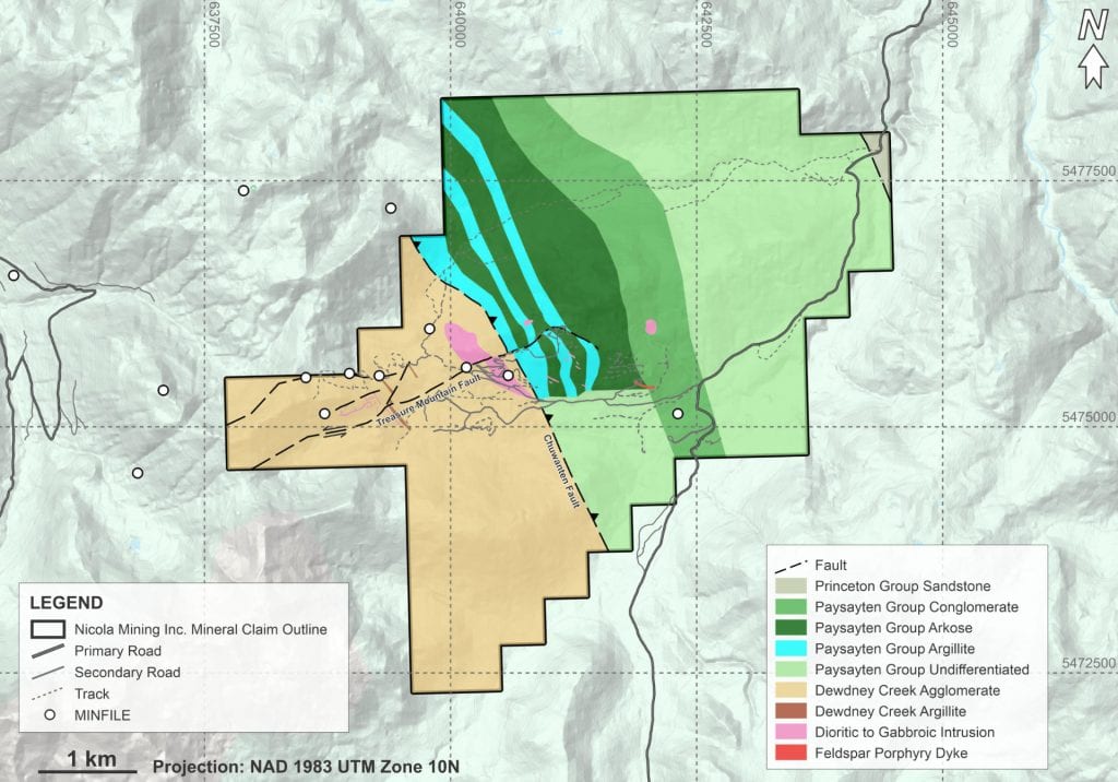
The principal Treasure Mountain vein(s) occurs in proximity to a local major fault, the Treasure Mountain fault striking 080° and dipping 30 to 65° south, and a feldspar porphyry dyke that partially occupies the fault. The vein strikes northeasterly and dips 50° to 65° southeasterly. Ore shoots within the vein extend from 50 to 150 m in length and vary in thickness from 0.5 to 1.5 m and occasionally to more than 2.0 m. The major mineralized vein, the “C” vein, has been explored from surface at 1,680 m elevation to about 1,390 m elevation, a dip distance of almost 350 m.
Treasure Mountain mineral veins are classed as “fracture controlled”, have little gangue and frequently feature central bands of massive mineralization with veinlets and disseminations distributed short distances outwards into the wall rocks. The major ore minerals are sulfides, including sphalerite, tetrahedrite, and boulangerite. Silver is present in native silver and tetrahedrite, and probably also occurs in significant amounts in galena and boulangerite. Ore minerals, along with quartz, were introduced along fracture zones proximal to a single feldspar porphyry dyke that may be an off-shoot from granitic bodies that lie a short distance from the mine area.
History of Treasure Mountain
In the 1930s, 4,000 tons of ore was mined, yielding 39,558 oz. silver, 379,532 lb. lead, and 88,455 lb. zinc, plus cadmium.[1] Silver Hill Mines Ltd. constructed a 50 tpd flotation mill in 1950, which is reported to have remained in place until at least 1956, though production is not recorded.[2] Huldra acquired early photos of the 1950s facilities, some of which are included in the historic photo gallery. Huldra Silver Inc. arrived at Treasure Mountain in 1980, discovered and exposed a silver-rich vein over a length of 250 m in 1985, and subsequently carried out drilling programs, geochemical soil surveys, and various technical studies.[3]
Between 1987 and 1989, exploration in the vein zone through four underground levels was conducted, comprising 9,000 feet of crosscuts, drifts, and raises, supplemented by 5,500 feet of underground drilling and 10,000 feet of surface drilling. Before undertaking the underground work, a bulk sample of 407 tons of select high-grade material from the surface vein showings was shipped to Cominco and Asarco smelters for testing. The smelters confirmed the compatibility of the shipments with their processing regimes and paid a total of $344,265 for the material, and Huldra subsequently opened up four levels totaling approximately 4,000 m of historic drifts. Historical records suggest that in 1989 Huldra submitted a prospectus to the Mine Development Steering Committee with the objective of placing the Treasure Mountain property into production, but the permitting process was not completed.[3][4][5][6]
Historical records state that the mine was ultimately permitted through a Notice of Work under the Mines Act to remove the 10,000 tonnes of ore from Level 1 of the underground mine before 2011/2012.[6] A camp was installed in summer 2011, while operations, namely exploration and development, began in September 2011. A Mines Act Permit was amended in 2012 for production of up to 60,000 tonnes per year.
Additional historical information on the Treasure Mountain property can be found in the official BC Government MINFILE database:
MINFILE No. 092HSW016 — Treasure Mountain
References
[1] McDougall, J.J., 1987. Report on Treasure Mountain Mineral Claims, Tulameen River Area, Similkameen Mining Division, British Columbia. Prepared for Huldra Silver Inc., J.J. McDougall & Associates Ltd.
[2] Ostensoe, E.A., Giroux, G.H., and Beaton, A.J., 2009. Technical Report: Resource Estimation, Mining and Reclamation Plan and Economic Evaluation, Treasure Mountain Property, Tulameen River Area, British Columbia. Prepared for Huldra Silver Inc.
[3] Huldra Silver Inc., 1989. Progress Report – Treasure Mountain Property.
[4] Meyers, R.E. and Hubner, T.B., 1989. Preliminary Geology of the Treasure Mountain Silver-Lead-Zinc Deposit. In: Exploration in British Columbia 1989, Geological Survey Branch, Ministry of Energy and Mines, British Columbia.
Historical Resource
The latest Mineral Resource Estimation was conducted in 2009 following CIM Definition Standards. The total vein Indicated Resource above a 10.0 oz/imperial ton cut-off was estimated to be 33,000 tonnes (metric) with 24.2 opt silver, 4.16% lead, and 3.80% zinc. The total vein Inferred Resource above a 10.0 oz/imperial ton cut-off was estimated to be 120,000 tonnes (metric) with 27.0 opt silver, 2.79% lead, and 4.36% zinc.[7]
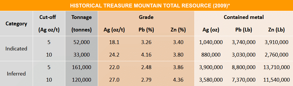
*A Qualified Person has not done any work to classify this historical resource estimate as current; therefore, Nicola Mining is not treating it as current. This historical resource estimate is considered reliable as it was carried out by Qualified Professionals and disclosed in accordance with NI 43-101. It is considered relevant because it is the most recent resource estimate available and would be the starting point for further work. It will need to be verified before it is expanded upon or upgraded since subsequent mining, including bulk sampling, has taken place.
Key Assumptions, Parameters, and Methods
- Mineral zone is a vein closely related to a feldspar porphyry dyke and is responsive to gentle folds or wraps in that dyke, defined by combined values of Ag, Pb, and Zn.
- Conceptual geological model with two solid domains: hangingwall (HW) and footwall (FW).
- Samples are assumed to represent the entire width of the vein and be oriented perpendicular to walls of vein.
- Based mainly on historic sampling (1987-1988). Sample locations were provided in digital form from mine plans: 850 sample strings from surface trenches (233), underground raises (11), underground drift samples (575), and drill holes (31).
- 1988 underground samples were validated by re-sampling in 2007 and comparing the two data sets; significant bias was apparent, with the 2007 results being lower for all three variables.
- A cap of 280 opt Ag was used to cap 7 assays, 56% Pb used to cap 5 assays, and 36% Zn used to cap 1 assay.
- Samples were composited to 0.75 m (2,235 composites for HW, 153 composites for FW).
- Pairwise relative semivariograms were generated for each variable along strike of the vein at azimuth 59°, dip 0°, and down dip at azimuth 149° and dip -55°. There was insufficient data across the vein to determine a model in this direction, so a nominal 10 m was used. Anisotropic nested spherical models were developed for each variable. The nugget-to-sill ratios for each variable were all considered high and indicated high sampling variability.
- A block model rotated into the plane of the vein was superimposed over the hangingwall and footwall vein solids.
- Block model blocks are 5 x 2 x 1.5 metres.
- Grades for Ag, Pb, and Zn were interpolated into the block model for any block that had some percentage within the vein HW or FW.
- Interpolation was done by ordinary kriging in a series of four passes using expanding search ellipses oriented along strike and down dip within the vein solids. The first pass required a minimum of four composites within a search area defined by one quarter of the semivariogram range. The second pass for unestimated blocks used an ellipse expanded to one half of the semivariogram range and required a minimum of four composites. A third pass used the full range and a fourth pass used twice the range. In all cases, if more than eight composites were found, the closest eight were used.
- Bulk density was calculated for each block based on its lead and zinc content. Lead was assumed to be contained within galena (SG = 7.5) and zinc assumed to be contained in sphalerite (SG = 3.9). Gangue minerals were assumed to have an SG of 2.7. Porosity was assumed to be 5%. Weight percents for each mineral were calculated as follows: wt% sphalerite = Zn x 1.49, wt% galena = Pb x 1.155, wt% gangue = 100 - 5 - wt% sphalerite - wt% galena.
- Starting with 2.57 (gangue 2.70 reduced by 5% porosity), the total SG is increased in 0.05 intervals in a series of iterations until the SG value accounts for the contained Pb + Zn.
- Volume % sphalerite = (wt% sphalerite x SG) / 3.90; volume % galena = (wt% galena x SG) / 7.50; volume % gangue = (wt% gangue x SG) / 2.70.
- Total volume % = volume % sphalerite + volume % galena + volume % gangue.
- If volume % = 100%, then SG = specific gravity of sample; if not, SG is incremented by 0.05 and the iteration is continued.
Work to Be Done to Upgrade or Verify as a Current Resource Estimate
- A review of as-built mine plans to determine what portion of the historical resource is still in-situ.
- Reconciliation between grade control and production data and the historical resource estimate.
- An audit of data used, including core logs, assay certificates, and a drill core inspection.
- A review of sampling methodology and documentation to ensure consistency with current best practices.
- Re-interpolation using the original assumptions and parameters to verify repeatability.
- Design and implementation of a more comprehensive exploration and drill program to verify, infill, and upgrade the historical resource, as required.
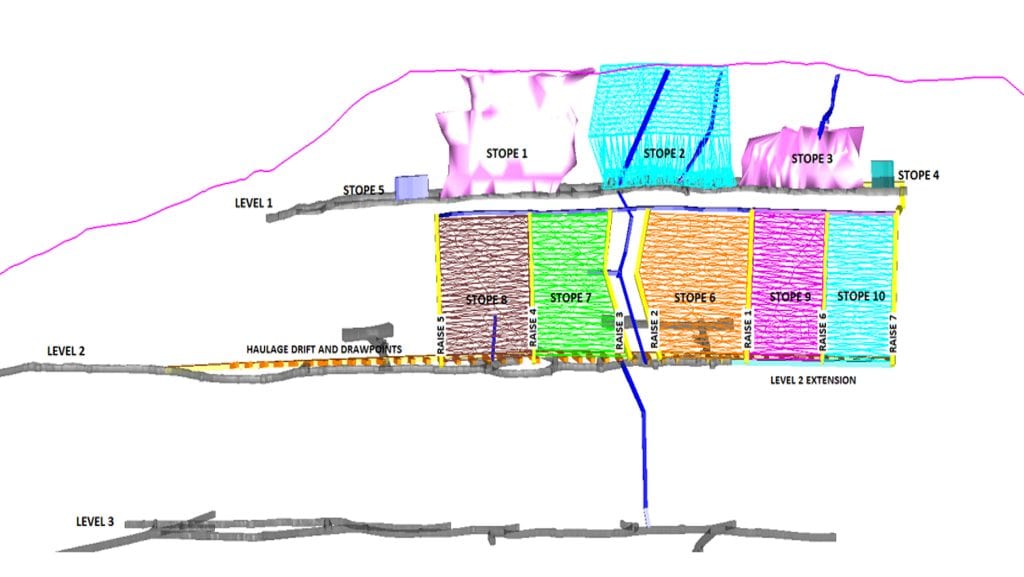
Nicola Mining Inc. completed a 10,000-tonne bulk sampling program on Level 1, while Stope 2 remains in situ.
The Company retains the option to reopen Level 1 to extract silver mill feed from Stope 2.
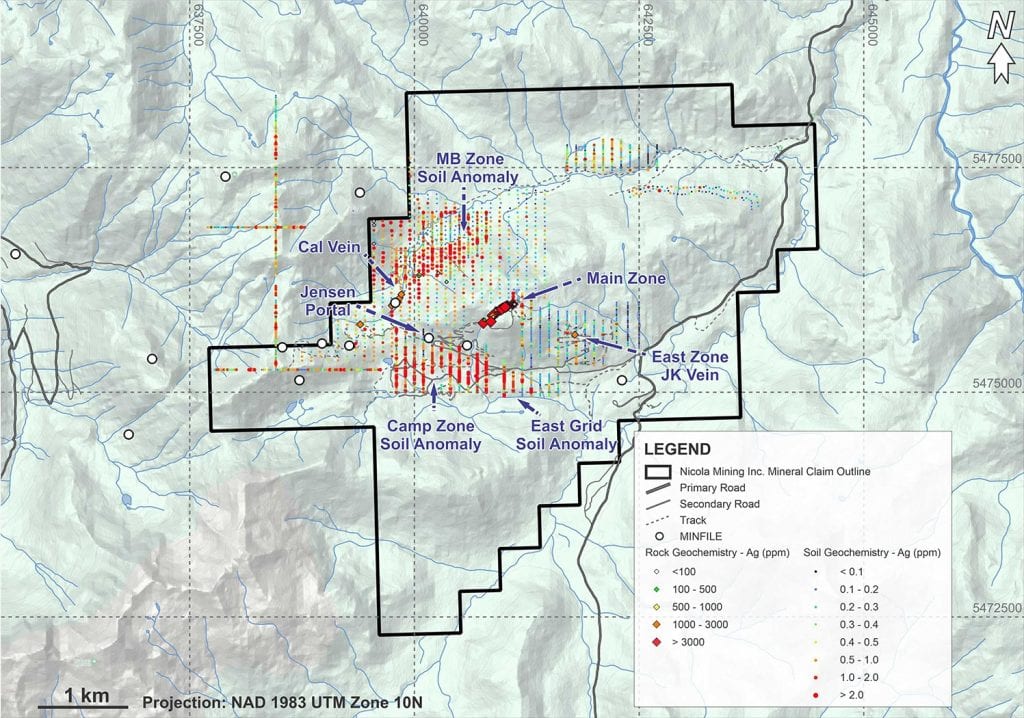
Potential Targets of Interest Moving Forward
- MB Zone located approximately 1.5 km from the underground mine workings on the undrilled northern backside of the mountain.
- JV Vein / Eastern Zone located approximately 1.0 km from the underground mine workings.
- Jensen Portal located approximately 100 m west of the Level 3 Portal and previously mined in the 1920s.
References
Recent Exploration
Since June 2011, exploration at Treasure Mountain has included diamond drilling, surface soil geochemistry sampling, surface and underground rock sampling on the upper two levels of the mine workings, a 10,000-tonne bulk sample, and a small exploration cut in the East Zone, located 8 km from the mine workings.
A total of 69 diamond drill holes, cumulatively spanning approximately 7,000 m, have been executed as part of the exploration strategy. Specifically, 51 diamond drill holes, covering a total length of 5,073 m, were strategically placed to target the main mine development area. This targeted drilling campaign was designed to enhance the resource definition within the upper 150 m of the mine’s infrastructure.[6][8][9][10][11]
Highlights from the drill program are presented in the following table.[6]
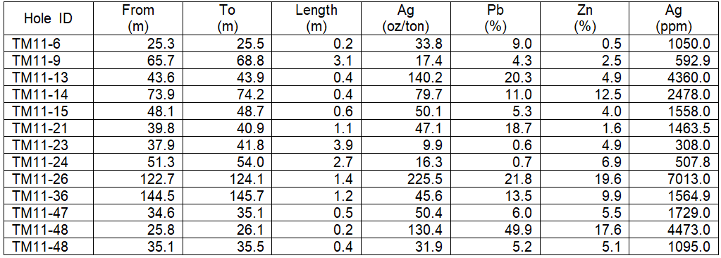
The complete list of drillholes are available in the following PDF.
Full disclosure was made in Assessment Report #39248 entitled “Assessment Report for 2019 and 2020 Exploration, Treasure Mountain Project, Similkameen Mining Division, BC, Canada” dated Dec. 13, 2020, prepared by Jacob Longridge.
In addition to drilling activities, the exploration team implemented soil geochemical sampling programs, collecting a total of 2,456 soil samples. These samples primarily focused on two zones of interest: the MB Zone and the Camp Zone. The MB Zone, situated approximately 1.5 km from the underground mine workings on the previously undrilled northern flank of the mountain, was identified in 2010 following the discovery of the Cal Vein. The Camp Zone, discovered through a geochemical testing program in 1996, exhibits a pronounced soil anomaly located below the Jensen Portal, stretching up to 1,000 m away from the existing workings.
Further rock geochemical sampling programs were undertaken, comprising 20 surface samples from the MB Zone and the Eastern Zone (JK Vein, approximately 1.0 km from the underground mine workings) and eight underground samples spanning a total length of 107 m from D Vein. The surface samples highlighted significant findings, including one sample from the Eastern Zone (JK Vein). The D Vein, initially uncovered 20 m into the hanging wall of the open cut at the top of Treasure Mountain, was then re-exposed through mechanical scaling.
References
[8] Huldra Silver Inc., 2011. Press Release: Development Update for Treasure Mountain.
[9] Huldra Silver Inc., 2012. Press Release: Bulk Sampling Program Commences at Treasure Mountain.
[10] Huldra Silver Inc., 2012. Press Release: Mines Act Permit Issued for Treasure Mountain.
| Regulatory | 2012 | Huldra Silver Inc. | |
| Regulatory | 2009 | Huldra Silver Inc. | |
| Material | 2008 | Huldra Silver Inc. | |
| Historical | 1989 | Huldra Silver Inc. | |
| Historical | n.d. | Huldra Silver Inc. |
Qualified Person
The scientific and technical disclosures included on this webpage have been reviewed and approved on April 1, 2026 by Will Whitty, P.Geo., who is the Qualified Person as defined by NI 43-101. Mr. Whitty is Vice President of Exploration for the Company.
